During a short visit to Liechtenstein last year, I learnt that it has the densest network of hiking trails in Europe. As an avid hiker, I was delighted to learn this. I only had time to hike above Vaduz, the capital, for a few hours. It had also rained when I visited. However I had been bitten by the bug. I was anxious to return to Liechtenstein soon and explore further.
A promotional pamphlet entitled “Princely Hikes” explained that you can hike from the top to the bottom of this country. I loved the idea of walking across a whole country – albeit a small one. So nine months later – I booked the trip and headed off on “The Liechtenstein Trail”. It’s a 75km hike through forest trails, farmland, residential and commercial areas.
Logistics
I arranged everything through the Liechtenstein Tourism Board’s website. My package included ;
- Hotel accommodation with breakfast
- Luggage transportation
- A packed lunch for each day
- The Liechtenstein Adventure Pass for the duration (includes free local buses)
- Access to the “Listory” app (although it’s free to download on the App store and Google play)
- A certificate upon completion
The 75km trail takes you through all eleven of Liechtenstein’s municipalities. I decided to walk for five days so I booked six nights accommodation. You could complete this in fewer days. Prices vary based on the season, which commences in June and ends in September.
The booking process was easy and I received a document outlining the items included, the address of each hotel and some basic instructions. One piece of luggage, weighing less than 20kg, is transported per person. You have to leave this in a designated area in your hotel before 9am each day and it’s guaranteed to be in your next hotel by 5pm.
The route starts in the south of Liechtenstein, near the Swiss border and ends in the north, close to the Austrian border.
I consider myself a fairly experienced hiker. Over the past twenty years I have completed some well known and quite challenging hikes including the Inca Trail, Everest Base Camp and to the summit of Kilimanjaro. I have also spent time hiking in Yosemite National Park in California, in the French and Italian Alps and in various parts of Switzerland.
The Liechtenstein Trail is categorised level 3 i.e. moderate – requiring a good degree of fitness. I think this is an adequate categorisation for the overall hike but there are several quite challenging sections.
The literature recommends you wear hiking boots but I think they are essential. I also recommend you bring hiking poles as I was certainly glad I brought mine.
Highlights of the trail
The scenery is absolutely breathtaking
It’s extremely safe to hike alone as a female
It has some challenging and enjoyable forest trails which most hikers will relish
Challenges of the trail
I went to bed hungry three nights from the five (more information on this will follow)
Navigation was a challenge at times. When should you follow the signs versus using the App?
This post (and two others) contains my overview of each day. I will describe what I consider to be the highlights and the challenges. I will also identify some “tips and quirks” based on my experience.
I travelled to Liechtenstein from Italy on two trains (Como to Zurich and Zurich to Sargans). The number 11 bus from Sargans (free with my adventure pass) took me to Triesen. I arrived in Triesen at 1.30pm and it was raining. When I was getting off the bus I saw a Thai restaurant called “Red Mango”. I had a wonderful red curry with tofu and vegetables for lunch. The portion size was quite large but as I had intended having an early night I wanted to have a large lunch.
It was easy to find my hotel – “Hotel Schatzmann Anstalt”. The owner checked me in and immediately commented on my hiking boots. She said lots of people arrive with unsuitable footwear. She gave me a bag tag (resting on linen bread bag in 4th image below) and instructed me to add my name and home address on it. She also told me some people write the address of the next hotel saying “we know where you are going so don’t need that”. I said “do you need my home address in case I die on the trail and you know where to return my luggage” ? She laughed awkwardly at my attempt at humour.


I bought a small salad in the Spar grocery shop and enjoyed it sitting on my balcony that evening. Triesen is very picturesque and is surrounded by mountains. There was a bad storm that evening and the mountains were lit up regularly by the spectacular lighting.
Day 1 – Balzers to Triesenberg, 16km
I slept really well and I hoped all my hotels would be this comfortable. My breakfast of scrambled eggs, toast, yogurt, fruit and coffee was delicious. I was given a “Liechtenstein” branded linen food bag containing a bottle of sparkling water, an apple and a cereal bar. I was told to make a sandwich from the food in the breakfast bar. My first lunch would consist of brown bread with cheese and a few cherry tomatoes.


When leaving my packed rucksack in the designated area, I asked the owner if any other hikers were starting that day. She told me I was the only one and the week before five people started on various days. I headed off to get the bus to the start, with a spring in my step. It was a cool morning but thankfully it was dry. Rain was forecasted for my first two days. I was careful with packing my day rucksack. While they can feel light at the start of a hike, that can change as you get tired. As well as my lunch, I had my camera, phone, walking poles, light long sleeved top, a waterproof jacket, my passport, a credit card and some cash.
I had downloaded the “Listory” app (image 3 and 5 above) the night before, changed the language to English and read the description of stage 1. I didn’t particularly like the idea of walking around looking at an app so I really hoped I could just follow the signs. The app has GPS tracking so I enabled location settings. The trail has eleven official stages. The length of each one and an estimated walking time is outlined. Some basic information about gradients, terrain of the route etc introduce you to each stage. Milestones are identified. These include historical buildings and geographical features. However, the information is extremely detailed and I wondered how much I would actually read.
The owner of the hotel had shown me a one page document, she had created, to show where the start is. I was to take the bus to Balzers and get off at “Hofle” bus-stop. The instructions said to continue straight ahead, following the traffic, to reach the start.

But I was about to make a costly mistake straight away.
The journey on the number 13 bus, took six minutes. I got out at the correct stop but immediately got confused. The bus went straight ahead, but all the traffic turned right. The two arrowed “Liechtenstein Weg” sign was pointing right and the way I came. I knew I would be walking back towards Treisen but now I wasn’t sure where the start was. I should have looked at the instructions the hotel gave me and ignored the signs. However, I decided to walk right. After walking through a commercial area, another sign pointed me to a forest path. This took me along a path which Balzers Castle overlooked. I knew from the app the route was via the castle. The app showed you that the another milestone was a lovely church in a small hamlet. Soon I passed that. However, this was meant to be my second milestone and I hadn’t reached my first milestone yet – the Swiss border. I really wanted to start the trail at the border as that seemed poignant.
I then walked along a really flat path through a field and by a milk processing plant with lots of cows. These were not the first cows I would see over the coming days.

Guess what was at the end of the road ? The Swiss Border.


I then realised my mistake. My Fitbit showed I had walked 6,700 steps and I was about 45 minutes into my journey. It would have been easy to be disappointed by my mistake but to be honest I just laughed at my stupidity. I hoped this was the only error I would make.
Even though I could have walked straight back to the bus stop and picked the trail up there, I decided to backtrack and walk the official route. I was glad I did as I hadn’t really looked at the castle and it’s extremely impressive.


After I arrived back at the bus stop, the route then took me through the main street. I decided then I wasn’t going to use the app all the time. You “unlock” each milestone when you arrive at it. This then tracks how many you pass and what municipality you are in. While the explanations are extremely interesting, they are very detailed. I was very concerned about my pace if I stopped to read each one. I decided then I would just follow the signs and read at my breaks.
How hard can that be ? But I was about to make two mistakes very quickly !
I was walking on the right hand side of the road and I saw the next sign on the left side so I crossed over. Just off the street, there were two sculptures both positioned to view beautiful mountain peaks.


I continued walking for a few minutes and something in my head said I was going wrong. I checked the app and the GPS showed I should have turned right. I crossed over and walked back. I then came to the sign showing the correct way. The sign was very small and impossible to see from the opposite side of the road. I then realised I couldn’t just rely on the signs.
I continued walking and came to the next milestone “The Holy Roman Empire of the German Nation”. A seat and water font is situated at this milestone. It’s also at a cross roads with three other options and no sign !
I decided the trail was a flat road through a field. I continued on that for about three minutes. But when I glanced at the app the GPS showed I was to the right of the trail. I really didn’t want to make another mistake so I walked back to the water font. Surely there was a sign somewhere that I had missed. I looked all around the three streets but I couldn’t find a sign. Surely the trail passed by the water font so I decided then the GPS was incorrect. I put my phone away and walked along the path again and eventually I came to another sign.
Now reader you are probably thinking this post will never end if I continue with this level of detail !
It will – but I thought it was important to explain my error and my experience with the signs and the app.
I decided then and there I would just check the milestones occasionally. I would read the descriptions when I stopped and would try and rely on the signs. But I knew I was going to have to be extremely vigilant to mitigate the risk of missing a sign. If you are hiking with a group you’d have more eyes to rely on !
The rest of the morning was spent walking through a lovely forest trail. It wasn’t very taxing as it was relatively flat. I thoroughly enjoyed it as this was exactly the type of countryside I wanted to spend time in.
Just as I started to feel hungry I arrived at a campsite. There were a few park benches scattered around. So I settled myself on one. Food always tastes better outside and I thoroughly enjoyed my first lunch. I saw a sign to public toilets and decided I would avail. However the cleaners were not happy with me. While they said I could use them – they told me they are not for hikers and I wasn’t to use them again.
Shortly after lunch I got my first glimpse of the river Rhine as it meandered its way through Liechtenstein. From above it appeared to be a soft shade of green. I hoped to confirm this if the trail took me closer over the coming days.


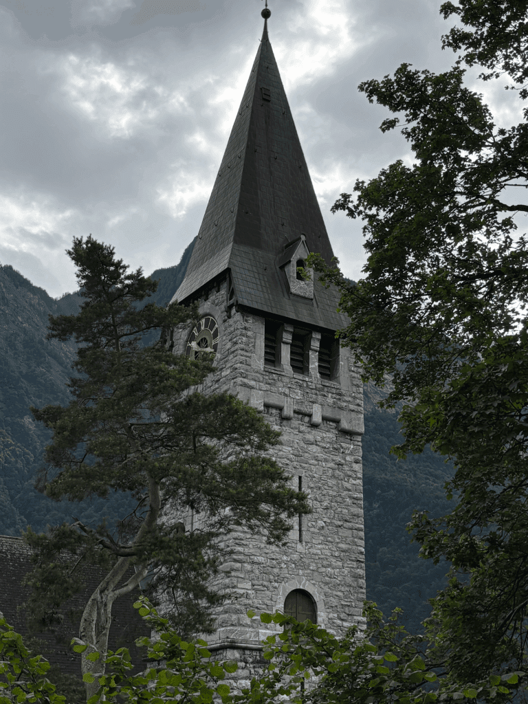
I really didn’t expect to see so many churches but every little village seemed to have a more picturesque one. I was surprised by how many I saw in close proximity to one another.

My two water bottles were now empty and I was starting to feel the effects of the trail and the heat. I filled one up at a water fountain in a residential street, a little while later. While I did pass some streams in the countryside I was reluctant to use them as there seemed to be animals everywhere.
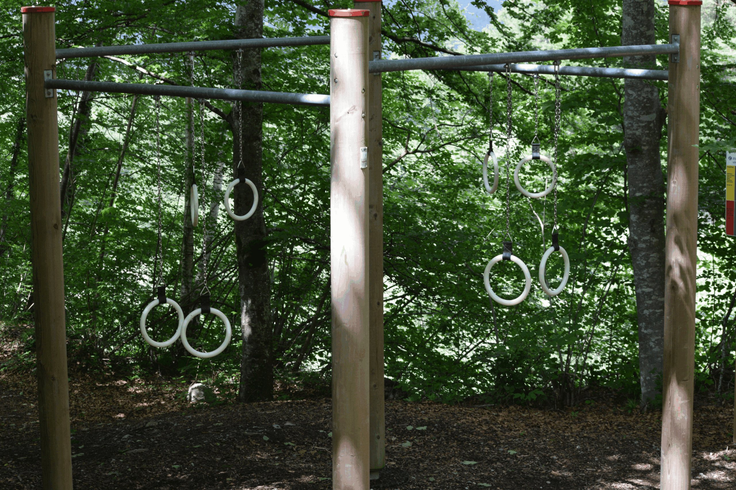
The last section of the day was a very steep climb through a forest trail. There was a grotto just before the entrance to the forest. Also, a few minutes into the forest I came to a workout area. I was amazed to see this and the equipment was in great condition. Naturally I was way too tired to try out anything ! I didn’t realize this is quite a common amenity in the forests here.

The trail was extremely narrow with a steep drop to the right (image below) . I was starting to get tired so I was very glad to have my walking poles with me. They gave me some stability and helped me get up some steep steps – often a challenge when you are short like me. There were lots of signs in the forest area. The Liechtenstein Trail signs are the red and blue ones below.


Just after 3pm I arrived at Triesenberg. I walked off a mountain path and this picturesque town seemed to be perched on a mountain. The hotels are not listed in the app so I used “Maps” to locate mine. The Hotel Oberland was a six minute walk up a steep hill from where I was standing. I was delighted to finally get to the hotel which overlooked the town.

I was about to realise I had made yet another mistake !
The front door was locked and the hotel appeared to be deserted. Detailed instructions on the door showed you needed a room key or credit card to access it. I sat on one of the seats outside and searched my email to see if I had missed some instructions. In my junk mail I found an email saying I was to check in online before arrival. So I checked in and was allocated room 42. I then used my credit card to open the door. To the side of the lovely wooden interior I saw a check-in machine. After submitting some quick details I was able to activate a key card.
Off to the side I spotted my rucksack. I was delighted as I was starting to shiver and knew I needed a hot shower. To my dismay there was no lift and my room was at the very top of a small staircase. There were forty steps to get me to my room.
While spotlessly clean my room was very small and basic. I took a shower quickly and changed into some fresh clothes. I was very glad I had brought flip flops with me as my feet really needed to breathe.
The literature in the room explained there was no restaurant on-site but listed several in the town. When I googled each one they were all downhill. I really didn’t fancy the climb uphill again today. My Fitbit showed I had completed 23km and 35,626 steps. I had walked far enough for the first day.
I went downstairs and located an “Honesty Bar” in the breakfast area. My evening meal consisted of a banana leftover from lunch, a packet of peanuts and a cold beer from the bar. Coffee and tea was available complimentary. I was glad I had cash with me to be able to purchase these items and have an early night. By the way, I didn’t see a single soul in the hotel that evening.
I wanted to organise myself for the following day but the app wasn’t accessible so I had to delete it and download it again. This resulted in deleting the milestones and municipalities I had visited today. I wondered how I would prove I had completed the trail. The competitive side of me really wanted the promised certificate !
Despite the challenges of the day – I had thoroughly enjoyed myself. While I clearly had made several mistakes, I was delighted with how I had coped and I had made good time, considering I walked a few extra kilometres. This wasn’t a race and I just needed to walk at my pace, enjoy the scenery and get to each hotel.
Main lessons learned from day one:
- I have mixed opinions on the usefulness of the App. There is too much detail to read and the GPS can’t be relied on. It didn’t have some of the information that I would like as a hiker i.e. more accurate description of the difficult parts, suggestions on where to stop to eat lunch and public toilets hikers can use
- You need to be extremely vigilant to ensure you don’t miss a sign, especially when walking in the towns and villages
- I think you need walking poles
- I recommend you review instructions for hotels in advance
- This is a unique country. I didn’t expect to see cows and vineyards so close to residential areas. I would see many more of both of these over the coming days !


According to the app I had completed two stages and I had walked 15.4km
Balzers to Triesen – 10km, official estimated walking time = 2 hrs and 30 mins
Triesen to Triesenberg – 5.4km, official estimated walking time = 1 hr and 50 mins
If you enjoyed this and want to read more – my posts on the remaining days are available :
Thank you for reading this – all comments appreciated below.
4 thoughts on “Overview and Day 1 of the 75km Liechtenstein Trail”
I have the worst sense of direction, so once I got off the bus, I would have got turned around and probably ended up having to live in a cave until someone found me, so you did well! What an amazing experience overall, and some really beautiful spots to spend time in.
Thanks for reading and commenting Molly. I did make day 1 more difficult than it needed to be.
But it was a great day. I have 2 more posts covering the next few days.
Thanks again, best wishes to you – Elizabeth